

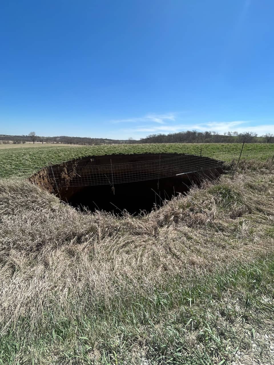
Marion County received the final site investigation report from the Iowa Department of Agriculture and Land Stewardship (IDALS) on May 4th regarding the sinkhole located on 135th Place.
A meeting with interested parties was held on May 11th to discuss the report and next steps. Bruening Rock Products owner of S&S Quarries located West of 135th Place has compiled information related to the mined area relevant to the sinkhole.
Based on available information, IDALS concludes the sinkhole could not have been formed from an abandoned coal mine but has formed from a collapse in the limestone mine below.
This conclusion is based on the following reasoning:
1) Even though the limestone quarry indicated they did not mine this far south, their maps are not very detailed or georeferenced to the surface.
2) Even though the limestone quarry stated there is no evidence of roof collapse in their mine in this area, the MSHA inspector indicated the far southeast portion of the mine could not be accessed due to waste material and water present in this area.
3) Roof problems in this area of the limestone mine are known to exist based on a major sinkhole repair from the limestone mine that was completed in 2009. In addition, we understand conversations between Marion County and Bruening Products in the past included statements about other roof collapses in this portion of the mine which have not extended to the surface and are caused by weaker rock present in the roof.
4) Our borings only found one coal seam, which is unlikely to have been mined because of its small thickness. Furthermore, this coal seam was above the void found in the first boring. Even if coal was mined in this area, the extensive void of 21 feet found in the first boring cannot be attributed to a coal mine.
5) DNR records in the area do not provide shaft depths of underground coal mines. However, the DNR data indicates the mines in the areas included surface coal mining and slope underground mining, which indicate mined coal seams would be at a relatively shallow depth. Other drilling log information found confirm coal seams would be found in the upper portions of the bedrock.
6) A large void (21 feet total) was found in Boring 1 underlain by soft, disturbed shale bedrock. We heard from the quarry that the mined limestone in this area was around 20 feet total at a depth of about 200 feet. A mine collapse in the limestone quarry with an unstable roof provides a reasonable explanation for the results of the first boring.
IDALS is not authorized to spend grant money for mitigation of the sinkhole hole since it cannot be determined that it is or could be related to an abandoned underground coal mine. We recommend this report be provided to Bruening Rock Products for their use.
Marion County was on site various times during drilling. IDALS informed them that the boring in the road showed that a mine collapse under the road with an unstable roof is present. It is not possible at 135th Place Subsidence – Marion County this time to determine whether the remaining portion of the bedrock above the void will continue to collapse and cause sinkhole within the roadway and if so, at what rate.
The broken water line has a temporary fix with a connection that allows the new water line to extend along the surface. Additional settlement is possible around the sinkhole depending upon the mitigation methods used. Furthermore, the first boring indicated that future potential subsidence events are possible in this area. Therefore, we suggest the water line be rerouted away from this area if practical to reduce the risk of future repairs.